Single-Cell Thunderstorms
What Are Single-Cell Thunderstorms?
Single-Cell convection is characterized by the following:
- A convective cell consisting of only one updraft/downdraft
- Typically occur in isolation from other storms, but can still occur nearby other convective cells as outflows can trigger new cells in NO organized manner
- Occur in high CAPE, low SHEAR environments
- Short-lived; usually 30-60 minutes
- Not typically associated with the production of severe weather, but can be under some circumstances (discussed later on)
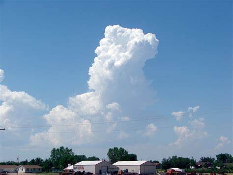
Ordinary cell thunderstorm in the towering cumulus (developing) stage. Courtesy of the National Oceanic and Atmospheric Administration (NOAA).
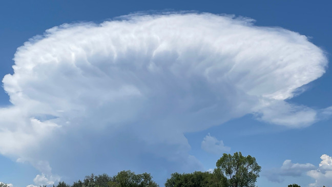
Ordinary cell in the mature stage of development with an overhanging anvil. Courtesy of KUTV in Salt Lake City, Utah.
Stages of Single-Cell Convection
Towering Cumulus Stage
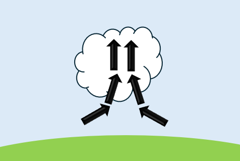
- Also referred to as the “Developing Stage”
- Occurs in regions where air parcels finally breach their level of free convection (LFC)
- No precipitation during this stage
Mature Stage
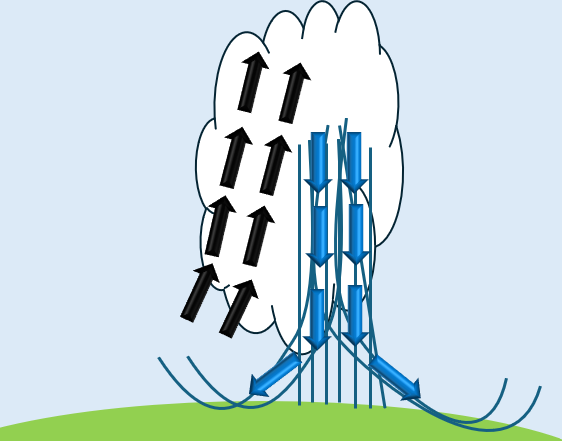
- This stage is characterized by being updraft dominant
- This leads to precipitation particles that do NOT fall back down through the updraft allowing it to maintain its intensity
Dissipating Stage
- This stage is characterized by being downdraft dominant, meaning that precipitation falls back down through the updraft, tearing the storm apart
- Buoyant air supply gets cut off
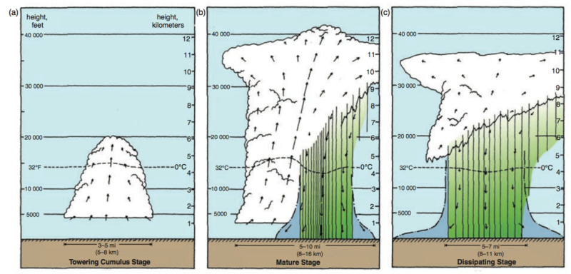
The three stages of an ordinary cell – (a) towering cumulus stage, (b) mature stage, (c) dissipating stage. Courtesy of Byers and Braham [1949] and Doswell [1985].
Environment That Supports Single-Cell Formation
- Weak vertical wind shear and weak large-scale forcing
- 0-6 km shear of less than 10.0 m/s
- Hodographs are not long or curvy
- Weak temperature/moisture advection
- This makes sense because there isn’t a lot of forcing available to provide the proper mechanisms which result in advection such as the low-level jet
- Convective Available Potential Energy (CAPE) ranging from a few hundred J/Kg to > 2,000 J/Kg
- Warm/moist air mass present
How Do They Form?
Necessary Ingredients:
- Lift
- Typically resulting from areas of weak, low-level convergence caused by differential surface heating
- Can be generated by way of upslope flow across hilly/mountainous terrain
- Outflow boundaries generated by preceding convection
- Moisture
- Sufficiently moist air mass present over a region – characterized by higher dewpoints
- Instability
- Warm/moist air mass in conjunction with steep environmental lapse rates present over a region result in areas of higher CAPE, conducive to thunderstorm formation
How It All Comes Together?
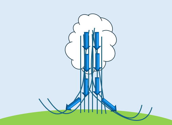
- Regions of low-level horizontal convergence (HCON) will lift air to its lifting condensation level (LCL), which is the point at which a lifted air parcel will become saturated. Beyond this point, if lifting continues, the parcel will eventually reach its level of free convection (LFC) only if the environmental lapse rates are sufficiently steep (instability). This is the point at which an air parcel becomes warmer than its surrounding environment, thus becoming positively buoyant. The parcel will freely rise until it is no longer warmer than its environment, at which point it is said to have reached its equilibrium level (EL). This is the process that results in the formation of the cloud/precipitation contained within the thunderstorm. This process continues unimpeded until one or both of the following occurs: Precipitation falls back down through the updraft, tearing the updraft apart and/or the warm/moist air supply gets choked off, leading to the dissipation stage.
Under What Circumstances is Severe Weather Produced?
- Typically occurs when the environment is characterized by the higher end CAPE values > 2,000 J/Kg
- When severe weather occurs, it is primarily of the pulse variety – meaning short-lived with the main threats consisting of:
- Strong wind gusts – usually occur in regions where strong downdrafts reach the surface and spread laterally outwards
- Small hail – Depends on the height of the freezing level (FL) & updraft speed
- Downdraft enhancements can result when precipitation falls through a relatively dry layer resulting in evaporation, negative buoyancy, and the downward acceleration of the air towards the Earth’s surface
- Occurs most often between the transition from the mature stage to the dissipation stage which is characterized by being downdraft dominant
Radar Identification
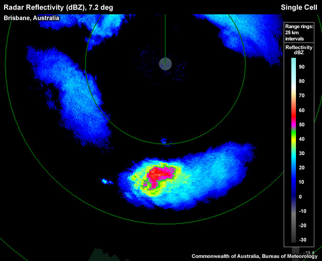
Ordinary cell thunderstorm seen on radar reflectivity. Characterized by one single cell which contains only one updraft/downdraft. Courtesy of the Commonwealth of Australia, Bureau of Meteorology and Luther College.
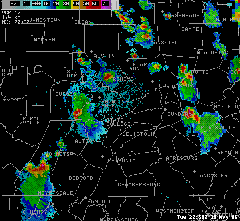
Single-cell convection on radar reflectivity across the Commonwealth of Pennsylvania. Some storms in close proximity to one another may be explained by a storm’s outflow boundary generating a new storm nearby. Courtesy of the National Oceanic and Atmospheric Administration (NOAA).
Tips & Tricks for Identifying Ordinary Cell Thunderstorms on Radar Reflectivity
- Look for single cells that are said to be “pulse” like since they pop up very quickly and are extremely short-lived (30-60 minutes on average)
- Understand the environment – Having knowledge of the environment will significantly help you to decipher what kind of convection you may be seeing on radar reflectivity.
- For instance, knowing the environment is characterized by high CAPE/low shear would lead one to believe it is ordinary cell convection being seen.
- Typically, ordinary cells occur in isolation from one another
- When you notice multiple convective cells in close proximity, pay attention to new cells forming. Are they forming in any organized/consistent manner on a preferred flank? If it appears to be more randomized, that will indicate ordinary cell convection as opposed to multi-cell
- Practice, practice, practice!!