Multi-Cell Thunderstorms
What are Multi-Cell Thunderstorms?
Multi-cell thunderstorms are characterized by the following:
- Organized group of convective cells
- Consists of convective cells in all stages of development such as the: towering cumulus stage, mature stage, and dissipation stage (for more information on thunderstorm stages reference the Single-Cell section by clicking the button down below)
- New cells form on a preferred flank determined by environmental vertical wind shear, outflow boundary characteristics, and other atmospheric variables
- Can be associated with severe weather
- Capable of lasting several hours as new storms continue to form
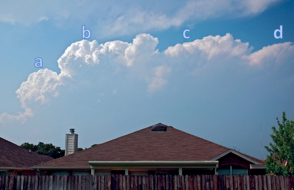
A multi-cell thunderstorm with the four stages of thunderstorm development being depicted. (a) Towering cumulus/developing stage, (b) mature stage, (c) dissipation stage, and (d) orphan anvil. Photo courtesy of the National Oceanic and Atmospheric Administration (NOAA).
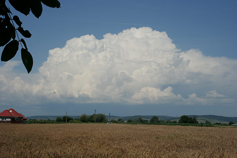
A multi-cell thunderstorm showing new to old cells from left to right across the image. Photo courtesy of Thunderstorm Photography Blog.
Characteristics of Multi-Cell Convection
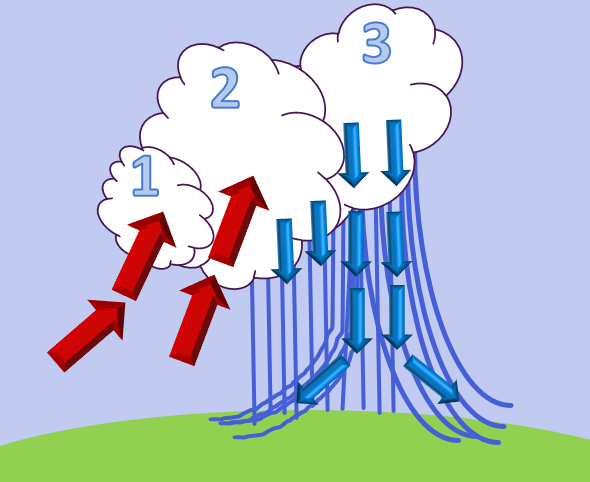
What this all means:
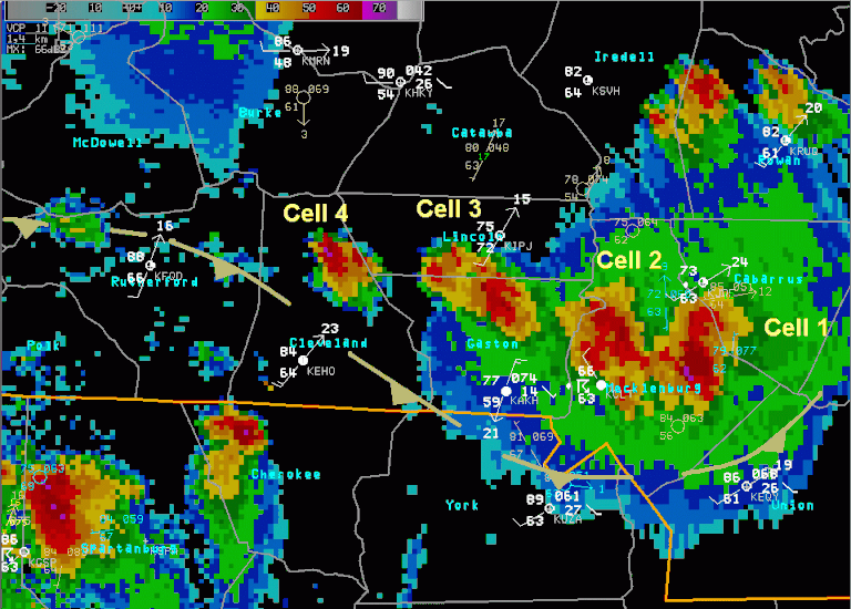
- Cell (1) is just beginning to form by way of air reaching its LFC, forming the buoyancy driven updraft inside of the cloud.
- Cell (2) is in the mature stage of development. This means that the convective cell possesses both an updraft/downdraft with precipitation NOT falling back down through the storm’s updraft. This maintains the storm’s intensity.
- Cell (3) is in the dissipation stage. The storm is now completely cut off from any moist/warm air supply. This stage is characterized by being downdraft dominant.
- Orphan Anvil – Composed entirely of ice crystals and will slowly sublimate into oblivion. (Not pictured here)
Environments Conducive to Multi-Cellular Storms
Environmental Characteristics Supportive of Multi-Cell Thunderstorms:
- Warm/moist air mass
- Moderate 0-6 km vertical wind shear
- Values within the range 10.0 – 20.0 m/s
- Instability
- CAPE values ranging from just a few hundred J/Kg to greater than 2,000 J/Kg
How Do They Form?
- The individual cells comprising the multicellular clusters form via the same mechanisms discussed in the “Single-Cell” section
- Multicellular convection is formed from the repeated development of new cells on the preferred storm flank
- Typically, the preferred storm flank for new cell formation is the downshear flank of the outflow – This is the result of a combination of lift resulting from environmental wind shear and that resulting from the storm’s outflow
- On this flank, the vorticity (spin) generated by the environmental wind shear and the storm’s outflow are in opposite direction which enhances the lifting of air parcels to the LFC in this location
- On the opposite flank, convection is actually suppressed
- See figure below for a better understanding of this concept
- The gust front relative wind also plays a role on the preferred flank for new cell generation
- The stronger the gust front relative winds, the greater the horizontal convergence and thus, there is enhanced vertical motion
- The preferred flank can also be influenced by other factors such as moisture characteristics, temperature characteristics, and terrain
- Typically, the preferred storm flank for new cell formation is the downshear flank of the outflow – This is the result of a combination of lift resulting from environmental wind shear and that resulting from the storm’s outflow
- This process of old cells dissipating and new cells forming/replacing the old cells continues until the process gets disrupted
- This disruption can result from:
- Environmental heterogeneities
- Changing environmental wind shear
- Outflow choking off warm/moist air supply
- This disruption can result from:
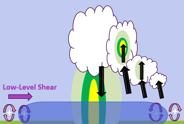
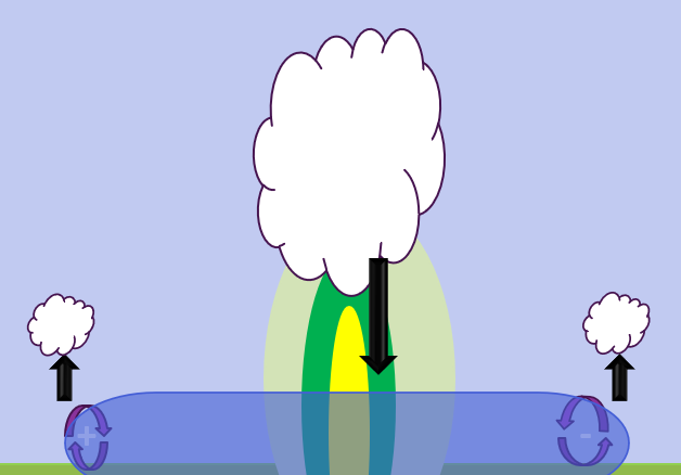
In this image you can see the low-level shear is westerly (pointed from left to right). On the upshear side of the storm’s outflow the baroclinically generated vorticity works against the vorticity generated by the environmental low-level wind shear. This results in convection being suppressed on the upshear side. Conversely, on the down low-level shear flank, both the baroclinically generated and environmentally generated vorticity work in conjunction to enhance upward vertical motion. Thus, the downshear flank is the preferred one for new cell formation. In order to simplify things, we neglected storm motion. Photo was adapted from “Mesoscale Meteorology in Midlatitudes” by Markowski and Richardson.
In this image, we ignore storm motion and vertical wind shear. This would mean that both flanks are equally as preferred in terms of new cell generation all thanks to the baroclinically generated vorticity. Photo was adapted from “Mesoscale Meteorology in Midlatitudes” by Markowski and Richardson
Storm Cluster Movement
System Motion
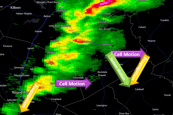
Cell motion vector, propagation vector, and the system motion vector for a cluster of thunderstorms over Texas on March 12th, 2025. Photo courtesy of RadarScope.
- The system motion is a combination of both the propagation vector and the cell motion vector
- Mathematically: (System Motion vector) = (Propagation vector) + (Cell Motion vector)
- Cell motion typically has a high correlation with the mean wind throughout the depth of the storm
- NOT true for supercells
- Propagation is determined by a multitude of factors, such as gust front relative winds, environmental wind shear, and atmospheric heterogeneities
- Some atmospheric heterogeneities that affect propagation are distributions of CAPE, CIN, moisture, temperature, etc…
- An example of propagation would be storms back building, meaning the cell motion vector is in the opposite direction of the propagation vector.
- Storms that back build can result in flash flooding events since they can produce large quantities of rain over the same region for an extended period of time
Radar Identification of Multi-Cell Thunderstorms
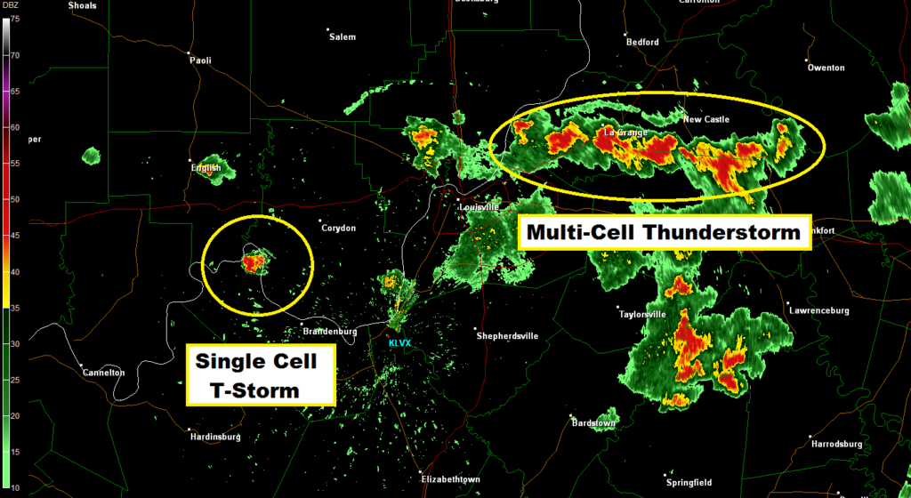
Radar reflectivity showing the difference between a multi-cell thunderstorm and a single-cell thunderstorm. Photo courtesy of Fox41 Meteorologist Jeremy Kappell.
Another multi-cell thunderstorm shown on radar reflectivity. Contains cells in all stages of development including the towering cumulus, mature, and dissipation stages.
Radar Identification Techniques:
- Identify convective cells in close proximity to one another where new cell formation appears to be organized/consistent on a preferred flank.
- Look for group of cells that move in conjunction with one another
- Have a good understanding of the background environment
- If you know there is moderate vertical wind shear present, then you as a forecaster will have a pretty good idea as to what type of storms to expect
- Also, having knowledge of the CAPE, CIN, moisture, and temperature distributions will assist in identifying storm type on radar
- Practice, Practice, Practice!
- Practice doesn’t make you perfect, but it certainly makes you better!