Supercell Thunderstorms
Whether you’re a high school student interested in weather, a weather enthusiast, or an aspiring meteorologist, this is probably the lesson you are most excited for! Rightfully so since supercells are termed the “Big Daddy” of thunderstorm type. This lesson is meant to give you a decent introduction and understanding of supercell thunderstorms.
What are Supercell Thunderstorms?
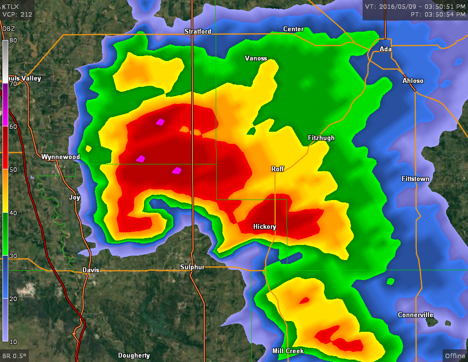
Radar reflectivity showing the classic supercell with a well-defined hook echo, weak echo region, and the classic storm split occurring with the left mover splitting from the right mover. Photo courtesy of the National Oceanic and Atmospheric Administration (NOAA).
Characteristics of Supercell Thunderstorms:
- Least common storm type
- Responsible for producing a disproportionately large amount of severe weather worldwide
- Contain a rotating updraft (mesocyclone)
- Responsible for the production of nearly all strong to violent (EF2+) tornadoes
- Possess a longer lifespan (60+ minutes) due to both environmental and dynamic effects which enhance updraft longevity
- Two types of classification – low-precipitation & high precipitation
- Most commonly occur in the central United States but can occur anywhere in the world under the correct conditions
Classic Supercell Structure and Dynamics
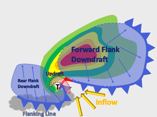
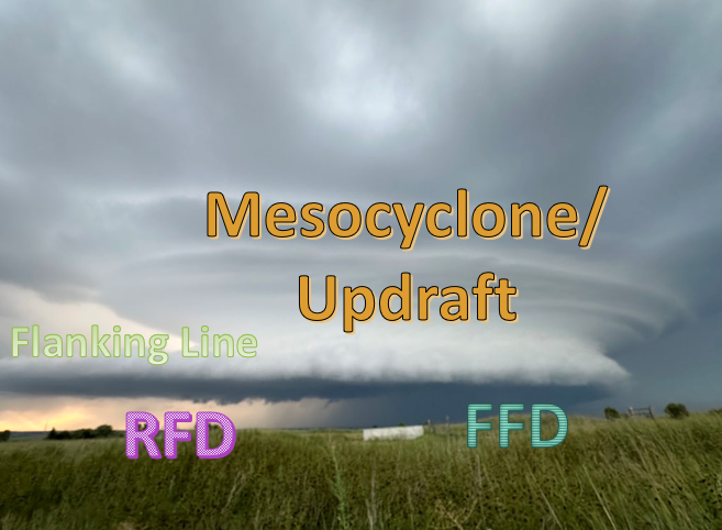
Supercell Structure
- Forward Flank Downdraft (FFD)
- Rear Flank Downdraft (RFD)
- Rotating Updraft (Mesocyclone)
- Hook Echo
- Flanking Line/Beaver’s Tail
- Wall Cloud
- Weak Echo Region (WER)
- Bounded Weak Echo Region (BWER)
Supercell Dynamics
- Perturbation Pressure Gradient Force (PPGF)
- Baroclinically versus environmentally generated vorticity
- Storm-splitting (left & right mover)
Supercell Structure
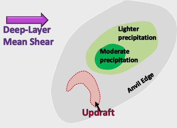
Forward Flank Downdraft (FFD)
- Located on the north/northeastern flank of the supercell
- Co-located with the region of heaviest precipitation
- Driven by precipitation particles dragging cool, dense air down to the surface, evaporational cooling, and melting
- Cold pool spreads out laterally on the ground and can generate “baroclinic vorticity” along the outflow boundary, which will be discussed later on in this section
- Can result in damaging surface winds
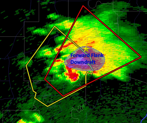
Radar reflectivity showing where the forward flank downdraft (FFD) is located within a classic supercell. Typically located on the north/northeastern flank. Photo courtesy of RadarScope.
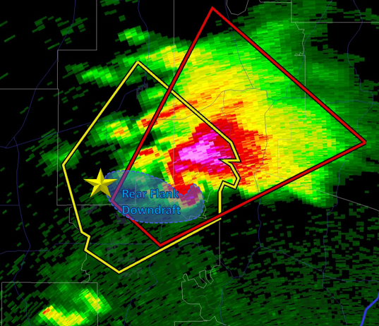
Radar reflectivity showing the region where the Rear Flank Downdraft (RFD) occurs within a supercell thunderstorm. Photo courtesy of RadarScope.
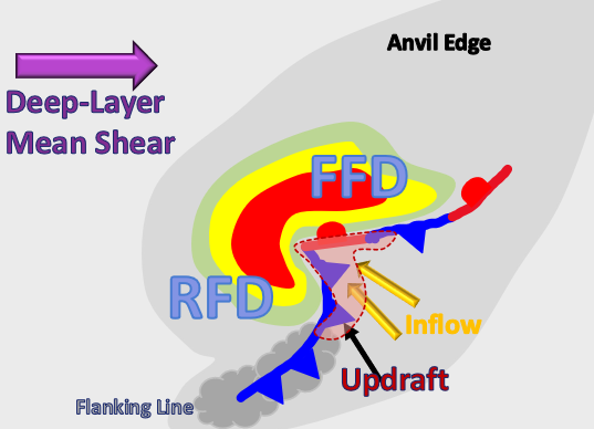
Rear Flank Downdraft (RFD)
- Located on the rear side of the storm
- Two main driving forces:
- Evaporative cooling caused by entrainment of drier air in the mid/upper-levels on the back side of the supercell resulting in the downward acceleration of negatively buoyant air
- Downward directed vertical pressure gradient force on the backend of the supercell helps to dynamically drive the rear flank downdraft
- The extent to which the RFD is thermodynamically versus dynamically driven is still an area of active research
- Another aspect to note is that temperature deficits in the RFD vary greatly from one supercell to another
- Typically, the air in the RFD is warm and dry
Rotating Updraft (Mesocyclone)
- This is what differentiates the supercell from any other storm type
- This rotation helps to give the mesocyclone the beautifully striated, mothership appearance
- What defines a mesocyclone? It is a region of vertical vorticity with an approximate width of 2-8 km and vertical vorticity with a magnitude on the order of (1/10² per second).
- Should extend over one-half of the entire storm depth
This photo shows the beautifully striated characteristic mesocyclone. The striations really help you to see the rotation even from just a still image. Photo courtesy of Kaylan Patel.
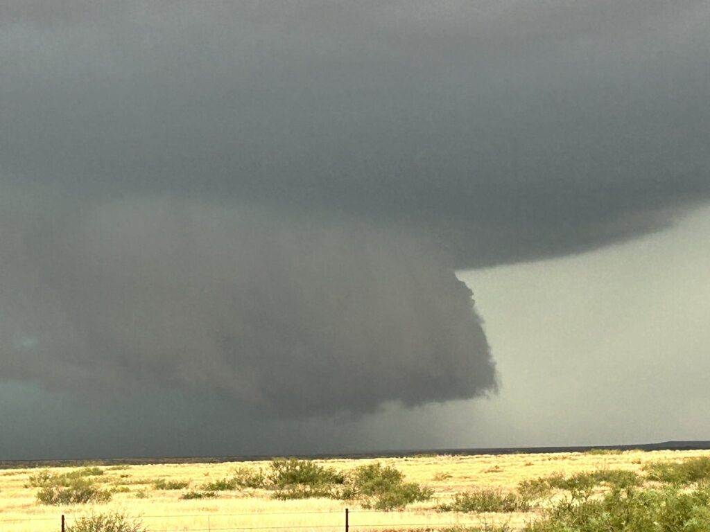
Photo of a low-hanging wall cloud. Forms due to moist, downdraft air being sucked into the updraft and condensing before the surrounding environmental air due to having a lower LCL. Photo courtesy of Jacob.
Wall Cloud
- A wall cloud is a low-hanging, rotating cloud underneath the mesocyclone portion of the supercell – Underneath the rain-free base
- The presence of a wall cloud does not mean a tornado will occur, but can signal that the environment is favorable for tornado formation
- Wall clouds also indicate the presence of a very powerful updraft indicated by the updraft’s ability to suck up cool, dense (negatively buoyant) air originating from the downdraft
How do wall clouds form?
- Wall clouds form when moist downdraft air originating from the FFD gets sucked up into the adjacent mesocyclone. This moist air will have a lower lifting condensation level (LCL) than the surrounding environmental air resulting in a lowering from the base of the updraft, which is the wall cloud
Flanking Line
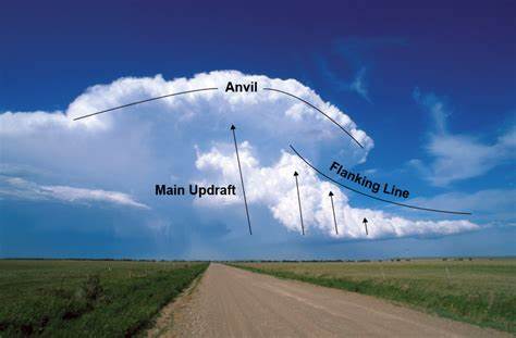
The flanking line forms on the rear of the storm along the outflow boundary originating from the RFD. The flanking line can help to support the main updraft by lifting warm, buoyant air to its LFC. Photo courtesy of National Oceanic and Atmospheric Administration (NOAA).
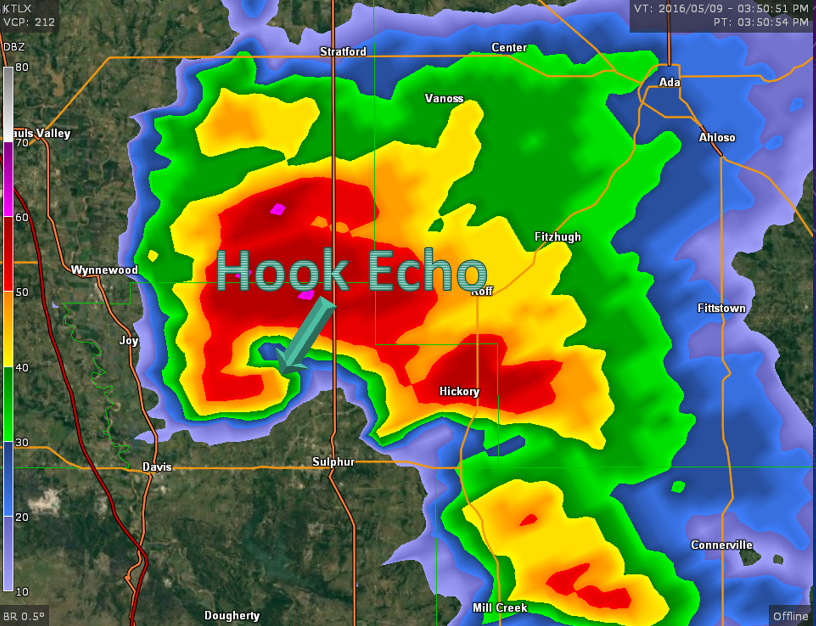
The hook echo is probably the most distinguishing aspect of the supercell seen on radar reflectivity. This feature forms from precipitation being wrapped around the back end of the rotating updraft with the updraft itself remaining very close to reflectivity-free due to precipitation not falling back down through the updraft. Photo courtesy of National Oceanic and Atmospheric Administration.
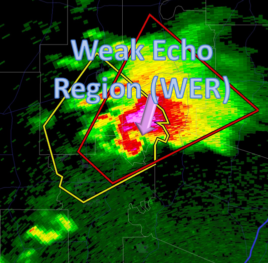
Radar reflectivity depicting the weak echo region co-located with the rotating updraft (mesocyclone) region of the supercell. You can clearly see the WER is a region of low reflectivity (dBZ) surrounded by regions of higher reflectivity. Photo courtesy of RadarScope.
Weak Echo Region (WER)
- The weak echo region (WER) is a low-level area of weak reflectivity seen on radar within the hook echo region
- The WER is co-located with the main updraft region of the supercell
How does the weak echo region form?
- The WER is formed because the strong upward vertical motion within the updraft suspends precipitation particles and doesn’t allow for them to pass back down through the updraft. This results in the region of weak reflectivity values within the hook region.
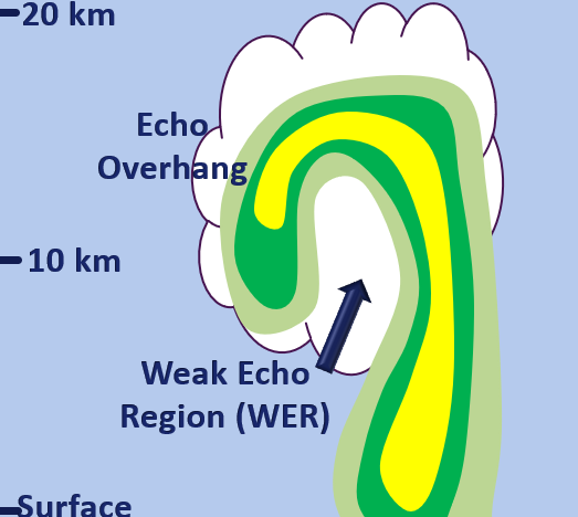
Diagram showing how the weak echo region (WER) is formed. The WER is co-located with the updraft region of the supercell which doesn’t allow precipitation to fall back through.
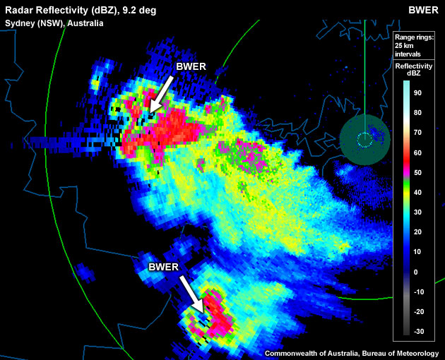
Radar reflectivity showing the bounded weak echo region of the supercell. The BWER is a region of weak radar reflectivity surrounded on all sides by higher reflectivity. Photo courtesy of Luther College.
Bounded Weak Echo Region (BWER)
- The bounded weak echo region (BWER) is a mid/upper-level storm feature seen on radar reflectivity
- The BWER is a region of weak reflectivity bounded on all sides by higher reflectivity values, indicative of significant overhang
- Co-located with the main updraft (mesocyclone) region
- Sometimes referred to as the “vault“
Supercell Dynamics
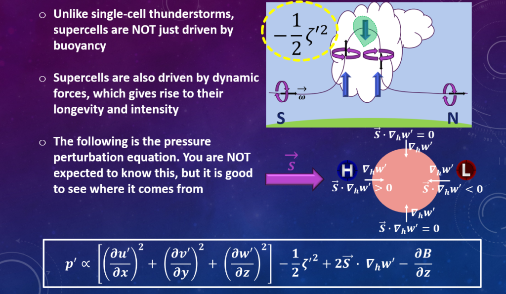
Perturbation Pressure Gradient Force (PPGF)
- Results in an upward directed vertical pressure gradient force that assists with updraft sustenance
- This is why, unlike ordinary and multicell storms, supercells can draw negatively buoyant air up into the mesocyclone
- The PPGF is driven dynamically by the nonlinear dynamic forcing and the linear dynamic forcing
- Also driven by vertical distribution of buoyancy through the updraft
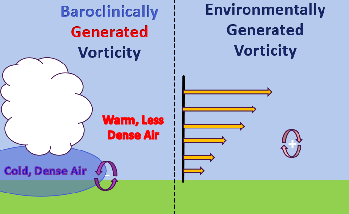
This figure depicts the difference between baroclinically generated vorticity and environmentally generated vorticity. The baroclinically generated vorticity arises from the cold outflow undercutting the warmer, less dense environmental air, resulting in vorticity. Similarly, environmental wind shear (speed & directional) result in tubes of horizontal vorticity which are ready to be ingested by an updraft, creating a mesocyclone.
Baroclinically versus Environmentally Generated Vorticity
- Environmental speed and directional shear lead to vorticity tubes (Horizontal Vorticity)
- Tilting of these horizontal vorticity tubes via the updraft result in counter-rotating vorticity couplets on either side of the updraft
- Environmental vertical wind shear gives rise to the rotating updraft, but does not explain the tornadogenesis process
- Rain-cooled downdrafts generate baroclinic vorticity closer to the surface, which does help to explain tornado formation
Storm-Splitting (Left & Right Movers)
- The effect of the nonlinear dynamic forcing term leads to updrafts on both flanks (right & left) with respect to initial storm motion
- This leads to the commonly observed phenomena of storm-splitting
- Updraft splitting results in right-moving and left-moving storm cells
- Right and left mover are defined with respect to the deep-layer wind shear vector (not necessarily the mean wind) – However, most times both are true
- The right (left) moving storm cell ingests more streamwise (antistreamwise) vorticity, respectively
- Streamwise vorticity being ingested by the right-moving updraft works to maintain the mesocyclone
- There is A LOT more that can be said on this topic, click the button below for an in-depth investigation on supercell propagation
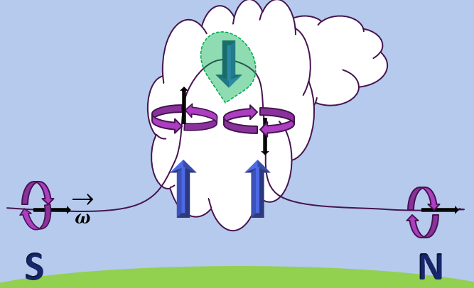
The nonlinear dynamic forcing term shows us that because the magnitude of rotation is greatest in the mid-levels of the storm, an upward directed PPGF develops on both storm flanks. These updrafts on both flanks results in the storm-splitting process.
Supercell Classification
Classic (CL)
- Contain most of their precipitation in the forward flank region with precipitation (rain/hail) wrapping around the back end of the mesocyclone, forming the classic hook echo appearance
- Most prominent severe weather producer including large hail and severe winds
- Tornado formation is most common in the CL supercell. This can be attributed to the following:
- The perfect balance of rain-cooled, downdraft air being present in order to generate baroclinic vorticity being sucked back up into the updraft
- This rain-cooled air is denser than its surrounding environment, but the air is not too heavy, thus allowing the cool, dense air to be sucked back up into the updraft
- If the air was too heavy, the updraft would not be strong enough to pull this air up from the surface
Low-Precipitation (LP)
- Most precipitation with a LP supercell occurs in the forward flank region
- Forward flank region is often disconnected from the main updraft
- Occur in environments characterized by lower precipitable water content when compared to their HP/CL counterpart
- LP storms tend to be visually appealing because their mesocyclone is not obscured by precipitation
- Associated with lower reflectivity values (< 45 dBZ)
- Some LP storms do not contain a rear flank downdraft
- Along with this, downdrafts in LP storms tend to be much weaker than within the CL/HP supercell
- Tornado occurrence is rare – The importance of the downdrafts in tornadogenesis will be discussed in the tornado development section
High-Precipitation (HP)
- Contain a large amount of precipitation in the forward flank region wrapping around the back end of the rotating mesocyclone/hook echo region
- Take on more of a kidney bean appearance
- Copious amount of precipitation can obstruct the view of the mesocyclone including any tornadoes that may form
- Tornado occurrence is not as common in HP supercells as they are in CL supercells
- Likely due to stronger/colder downdrafts, making it harder for the updraft to suck up this cold, dense air
- Higher reflectivity values
- Supercell classification is rather subjective
- It has been discovered that Supercell Type is interestingly enough, a function of storm-relative upper-level flow
- High-Precipitation Supercells tend to be favored for storm-relative upper-level (9-10 km) flow of < 12.0 m/s
- Classic (CL) Supercells tend to be favored for storm-relative upper-level (9-10 km) flow between 12.0 m/s – 33.0 m/s
- Low-Precipitation Supercells are favored for 9-10 km storm-relative upper-level flow > 33.0 m/s
Supercell Environment
Environments Conducive to Supercell Convection:
- Warm, moist air mass
- Can occur in environments containing a few hundred J/Kg of CAPE – 3,000+ J/Kg of CAPE
- Requires a sufficient supply of warm/moist air – low-level jet (LLJ) – draws warm, moist air northward from the Gulf of America
- Strong environmental vertical wind shear
- Deep-layer, 0-6 km shear values > 20.0 m/s
- Long, curvy hodographs – Indicative of the presence of strong vertical wind shear and storm relative helicity (SRH)
- Presence of a lifting mechanism to get air parcels up to their level of free convection (LFC)
- Can be a cold front, dry line, warm front, regions of low-level convergence, outflow from preceding storms, etc…
- Synoptic-scale forcing can help drive convection
- A lot goes into forecasting for supercell thunderstorms, more advanced topics will be discussed in the severe weather forecasting section
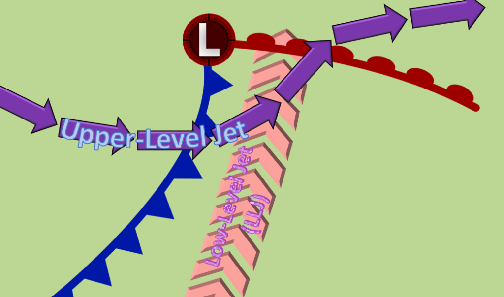
This figure depicts the basic setup for an environment that is conducive to supercell formation. Here, we have a low-pressure system along with its associated mid-latitude frontal systems [cold front & warm front]. In the warm sector, the presence of a moderate-to-strong low-level jet (LLJ) draws warm, moist air northward from the Gulf. Along with this, the LLJ provides additional low-level vertical wind shear, a necessary ingredient for supercell formation. In conjunction with this low-level ribbon of fast-moving air, the upper-level jet provides sufficient deep-layer wind shear, another vital component to the development of a supercell. The positioning of the associated trough is crucial in determining if warm sector supercells out ahead of the advancing cold front is likely. Upper-level divergence in the warm sector can help to provide regions of enhanced upward vertical motion (UVM), further increasing the likelihood of pre-frontal convection and thus, supercell formation. The complexity of the environment can sometimes make it difficult for forecasters to determine where/when convection may initiate.
Radar Identification of a Supercell
Supercell: Radar Reflectivity
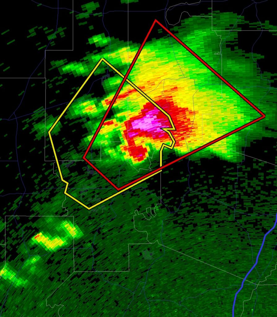
Radar reflectivity showing a Classic (CL) Supercell with high reflectivity values associated with its FFD along with a well-defined hook echo appearance located to the southwest of the forward flank downdraft region. Photo is of a supercell from Saturday, March 15th, 2025 – courtesy of RadarScope.
Supercell: Storm-Relative Velocity
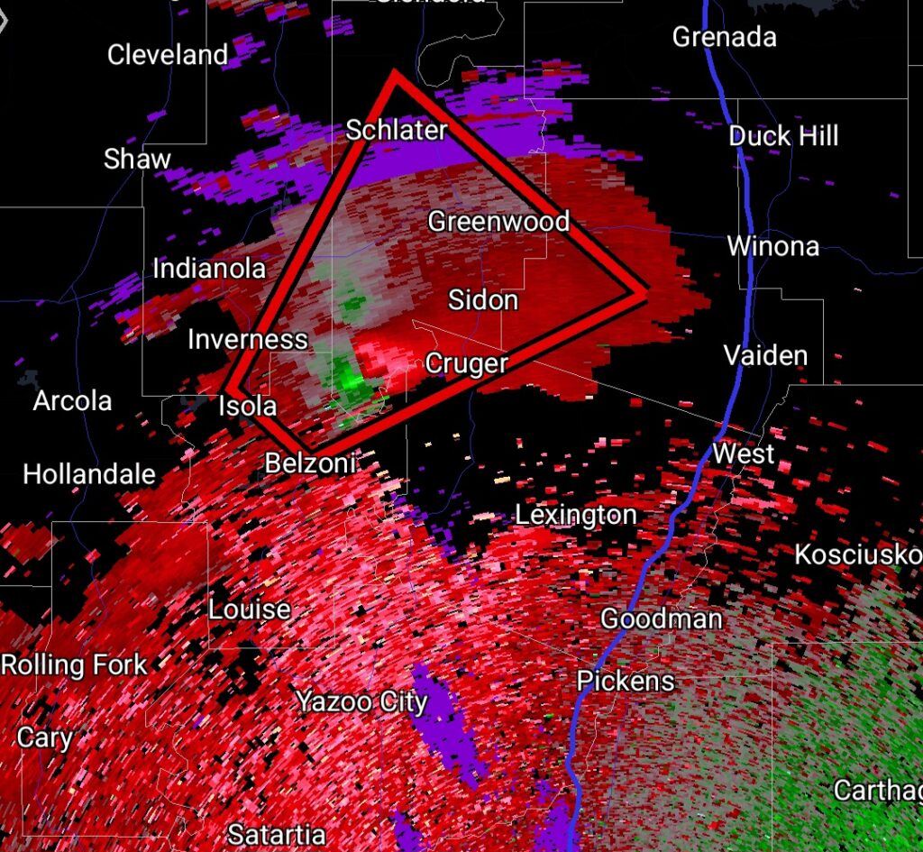
Storm-relative velocity showing strong mid-level rotation indicated by the tight inbound (outbound) or green (red) couplet just north of Yazoo City, Mississippi. Photo is of the same supercell shown in the radar reflectivity. There should be no doubt as to why the National Weather Service issued a tornado warning for this supercell. Photo is courtesy of RadarScope.
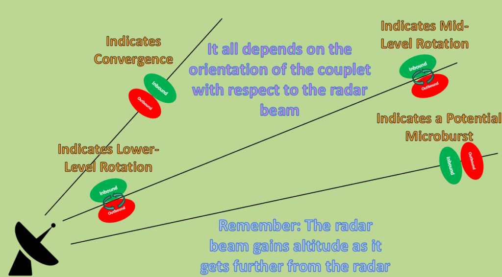
- Identifying Supercells Utilizing Radar Reflectivity and Storm-Relative Velocity:
- Look for a couplet of inbound (green) and outbound (red) velocities side-by-side on either side of the radar beam
- Knowing the orientation of the velocity couplet in relation to the radar beam is crucial
- This is because not all red/green storm-relative velocity couplets indicate the occurrence of rotation
- Another important note is that the rotation you are seeing via the storm-relative velocity feature is that of the low/mid-level mesocyclone, NOT the tornado
- A more in-depth radar lesson will be added to this website later on! Stay tuned for updates!!
- Look for the classic forward flank precipitation region with the hook-shaped appendage (“hook echo”) extending from the rear portion of the storm
- A lot of times, both high-precipitation (HP) and low-precipitation (LP) supercells do not have the “classic” supercell appearance on radar reflectivity
- Utilize storm-relative velocity in these cases to identify regions of rotation within the storm
- Knowing the environmental background can be extremely beneficial in identifying storm-type
- Practice, Practice, Practice!!!